


وصف لـ Disaster Alert
Disaster Alert is a free, mobile app that provides individuals, families, and their loved ones with the information they need to stay safe anywhere in the world. Built on PDC’s DisasterAWARE® platform, Disaster Alert™ offers near real-time updates about 18 different types of active hazards as they are unfolding around the globe.
With Disaster Alert, you can customize early warning alerts, view situational analysis reports, and access modeled hazard impacts for select hazards in a single, easy-to-use map interface. Disaster Alert’s continuous stream of new information is automatically derived from only scientifically verified sources. When no official source is available, alerts are updated manually, presenting a small lag in time.
INCLUDED HAZARDS
Hazard updates provided with Disaster Alert include only active hazards. “Active Hazards” are part of a collection of recent incidents that have been designated as potentially hazardous to people, property, or assets by PDC.
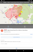
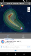
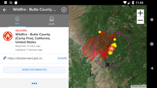
Global events (Automated): Hurricanes (tropical cyclones / typhoons), earthquakes, tsunamis, volcanos, floods, wildfires. Also included for the U.S. only are tornados and winter storms.
Other Major events (Manual): Marine hazards, storms, droughts, and manmade incidents.Also included for Hawaii only are high surf advisories, high winds, and flash floods.
*Additional hazards will be included as new sources and algorithms are identified and verified.
NEW IN VERSION 4
*NEW: Free, customizable hazard alerts based on location and severity, with automatic updates as each new advisory is released
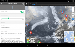
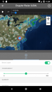
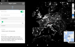
*NEW: Animated Layers (rainfall, clouds, winds, more…)
*NEW: Layers for tropical storm tracks and 20 other various incidents (including smaller earthquakes, etc.)
*NEW: Improved navigation and user experience, including user preferences for look and feel
*NEW: Support for select international languages (other languages are added over time)
OTHER KEY FEATURES
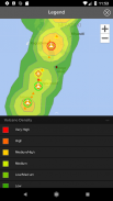
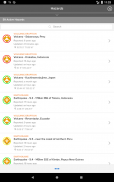
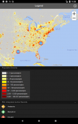
Interactive map interface displaying 18 different types of active hazards
Situational analysis reports including modeled impact analyses for select hazards
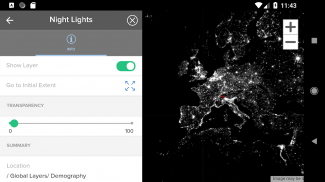
Customizable background maps
Map overlays with population densities, global cloud coverage, and more.
Disaster Alert هو تطبيق مجاني متحرك يوفر للأفراد والعائلات وأحبائهم المعلومات التي يحتاجونها للبقاء في أمان في أي مكان في العالم. بنيت على DisasterAWARE® منصة PDC ، يوفر Disaster Alert ™ بالقرب من التحديثات في الوقت الحقيقي حول 18 أنواع مختلفة من المخاطر النشطة لأنها تتكشف في جميع أنحاء العالم.
باستخدام ميزة "التنبيه من الكوارث" ، يمكنك تخصيص تنبيهات الإنذار المبكر ، وعرض تقارير التحليل الظرفية ، والوصول إلى تأثيرات خطرة من طراز معين لمخاطر محددة في واجهة خريطة واحدة سهلة الاستخدام. يتم اشتقاق التدفق المتواصل للمعلومات الجديدة تلقائيًا من مصادر علمية تم التحقق منها فقط. عندما لا يتوفر مصدر رسمي ، يتم تحديث التنبيهات يدويًا ، مما يؤدي إلى تأخر بسيط في الوقت المناسب.
تدرج المخاطر
تتضمن تحديثات المخاطر المقدمة مع "التنبيه من الكوارث" المخاطر النشطة فقط. "المخاطر النشطة" هي جزء من مجموعة من الحوادث الأخيرة التي تم تصنيفها على أنها خطرة على الأشخاص أو الممتلكات أو الأصول من قبل PDC.
الأحداث العالمية (المؤتمتة): الأعاصير (الأعاصير المدارية / الأعاصير الاستوائية) ، الزلازل ، أمواج تسونامي ، البراكين ، الفيضانات ، حرائق الغابات. وشملت أيضا بالنسبة للولايات المتحدة فقط هي اعصار وعواصف الشتاء.
أحداث رئيسية أخرى (دليل): المخاطر البحرية والعواصف والجفاف والحوادث من صنع الإنسان.كما المدرجة في هاواي هي فقط نصائح عالية تصفح ، والرياح العاتية ، والفيضانات الخاطفة.
* سيتم تضمين مخاطر إضافية عند تحديد مصادر وخوارزميات جديدة والتحقق منها.
جديد في الإصدار 4
* جديد: تنبيهات مخاطر مجانية وقابلة للتخصيص بناءً على الموقع وشدتها ، مع تحديثات تلقائية حيث يتم إصدار كل استشاري جديد
* جديد: الطبقات المتحركة (الأمطار ، السحب ، الرياح ، المزيد ...)
* جديد: طبقات لمسارات العواصف المدارية و 20 حادثة أخرى مختلفة (بما في ذلك الزلازل الصغيرة ، وما إلى ذلك)
* جديد: تحسين تجربة التنقل والمستخدم ، بما في ذلك تفضيلات المستخدم للشكل والمظهر
* جديد: دعم لغات دولية مختارة (تتم إضافة لغات أخرى بمرور الوقت)
ميزات رئيسية أخرى
واجهة خريطة تفاعلية تعرض 18 نوعًا مختلفًا من المخاطر النشطة
تقارير تحليل الموقف بما في ذلك تحليلات الأثر النموذجية لمخاطر مختارة
خرائط خلفية قابلة للتخصيص
تراكب الخرائط مع الكثافة السكانية ، وتغطية السحابة العالمية ، والمزيد.
Disaster Alert - إصدار 454.755.201
(19-04-2023)
Disaster Alert - معلومات APK
نُسخة APK: 454.755.201الحزمة: disasterAlert.PDCتطبيقات من الفئة نفسها
قد يعجبك أيضًا...


